Today

Time
| Z | EST | EDT |
|---|---|---|
| 00 | 7 pm | 8 pm |
| 03 | 10 pm | 11 pm |
| 06 | 1 am | 2 am |
| 09 | 4 am | 5 am |
| 12 | 7 am | 8 am |
| 15 | 10 am | 11 am |
| 18 | 1 pm | 2 pm |
| 21 | 4 pm | 5 pm |
| 24 | 7 pm | 8 pm |
Speed
| Knots | MPH |
|---|---|
| 5 | 5.75 |
| 10 | 11.50 |
| 15 | 17.25 |
| 20 | 23.00 |
| 25 | 28.75 |
| 30 | >34.50 |
Direction
| Dir | Degrees |
|---|---|
| N | 0 |
| NE | 45 |
| E | 90 |
| SE | 135 |
| S | 180 |
| SW | 225 |
| W | 270 |
| NW | 315 |
WX Roundup
Radar | NWS Enhanced | Wunderground | Continental US | Northeast |
Lightning: | Blitzortung |
Air Quality:
- PurpleAir - Monitoring Stations
- Environment Canada - Forecasts
- EPA AirNow - Alerts and Forecasts
Satellite Imagery - GOES 16:
| Water Vapor Band 9 | US Eastern Seaboard | Canada/US | North Atlantic |
| Infrared Band 13 | US Eastern Seaboard | Canada/US | North Atlantic |
| AirMass RGB | US Eastern Seaboard | Canada/US | North Atlantic |
| Geocolor | US Eastern Seaboard | Canada/US | North Atlantic |
NWS Point Forecasts:
| Fayston | South Hero | Burlington VT | Gloucester MA | Vero Beach FL |
| Recreation |
Area Forecast Discussions:
Indies:
Burlington NWS: | Mesoscale Maps | Cam Index | BTV Home
Current Observations:
GOES 16 Indexes: | East | Full Disk | Tropical Atlantic |
SST Anomaly: | Columbia IRI | Unisys |
Lake Champlain:
Mountains:
- Mount Mansfield VT: Current Weather | Snow Stake Graph | Snow Stake Data
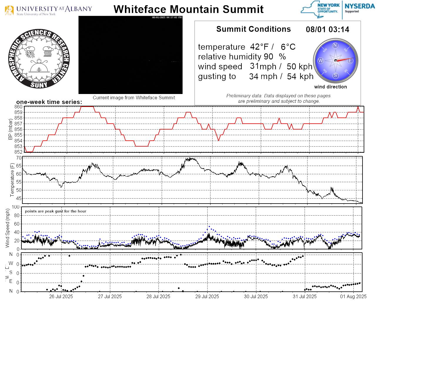
- Whiteface Mountain NY | MetData
- Mount Washington